Numerical modelling and forecasting
WP5: Drift Modelling and Prediction

For activities in Arctic waters or to predict the drift of icebergs, oil-spills and other pollutants, forecasts of ocean currents, sea surface temperature, the position of the sea-ice edge, and weather forecast are important.
CIRFA improves short-term ocean and weather forecasts for Norwegian coastal and offshore areas and quantifies their uncertainty.

Ocean, sea ice and weather forecasts at high latitudes are challenging due to few observations of oceanic ‘weather’. One way to resolve the lack of observations is including (assimilating) high-resolution satellite data into ocean and sea ice models.
Because of observational uncertainties, the forecasts have to be probabilistic; presenting a range of possible outcomes based on multiple slightly different model runs – also known as ensemble prediction systems (EPS).
Hence, CIRFA is developing new algorithms for data assimilation and ensemble forecasting that may become part of operational ocean and weather forecasts. Forecasting models that are currently used by MET Norway are adapted and tested in their new configurations.
Research tasks
Quantification of forecast skill in ocean current predictions from the Barents-2.5 EPS.
Improving SAR-based wind retrieval algorithms in polar low and extreme wind situations.
Application of the Ensemble Kalman Filter data assimilation scheme in the regional ocean and ice forecast model Barents-2.5.
Application of ensemble forecast methods in trajectory modeling.
Assimilation of sea surface temperature observations from various platforms in the coastal forecast model NorKyst.
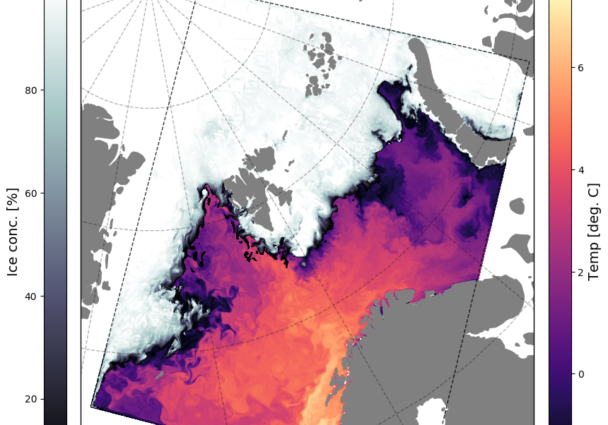
Ocean, sea ice and weather forecasts
Data assimilation techniques combine the weather forecast models with various types of ocean and sea-ice observations, providing an analysis of the ocean’s state and sea ice cover. For activities in Arctic waters, critical forecast parameters are the position of the sea ice edge and ocean currents as well as the weather.
Forecast models for the ocean and sea ice cover predict the conditions 1-3 days ahead in two steps. In the first step, the forecast systems ingest observations from remote sensing and in-situ platforms to estimate the current state of the ocean. In the second step, the ocean’s state is projected forward in time by solving physical laws numerically.
In its present configuration, the Barents 2.5 model can forecast sea ice extent and surface temperature between 24 and 66 hours ahead. This includes predicting the uncertainty in surface current forecasts. Read more about the Barents 2.5 model here.
Polar Lows and extreme wind situations
Team members

Johannes Röhrs
WP5 co-leader, MET Norway

Rune Graversen
Professor and WP5 co-leader, UiT
Atmospheric circulation, climate dynamics and polar meteorology

Mathias Tollinger
PhD candidate, UiT
Using Synthetic Aperture Radar (SAR) to improve prediction of Polar Lows

Martina Idzanovic
PostDoc, MET Norway
Drift modelling and prediction

Ann Kristin Sperrevik
Researcher, MET Norway

Silje Christine Iversen
PhD candidate, UiT and MET Norway
The impact of observations in a high-resolution ocean assimilation system for the Norwegian coastal and shelf seas

Victor de Aguiar
PhD candidate, UiT
Oil Spill Remote Sensing and Modelling

Yvonne Gusdal
Researcher, MET Norway

Edel Rikardsen
Researcher, MET Norway
Edels work focuses on cean modelling and computational physics

Kai Christensen
Researcher, MET Norway


